


SEVENTY-SIX TWP Voting District, Washington County, Iowa
About
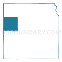
Outline

Summary
| Unique Area Identifier | 583656 |
| Name | SEVENTY-SIX TWP Voting District |
| County | Washington County |
| State | Iowa |
| Area (square miles) | 36.54 |
| Land Area (square miles) | 36.53 |
| Water Area (square miles) | 0.01 |
| % of Land Area | 99.96 |
| % of Water Area | 0.04 |
| Latitude of the Internal Point | 41.37417640 |
| Longtitude of the Internal Point | -91.89744990 |
Maps


Graphs
Select a template below for downloading or customizing gragh for SEVENTY-SIX TWP Voting District, Washington County, Iowa


Neighbors
Neighoring Voting District (by Name) Neighboring Voting District on the Map
- CEDAR TWP Voting District, Washington County, IA
- CLEAR CREEK TWP Voting District, Keokuk County, IA
- DUTCH CREEK TWP Voting District, Washington County, IA
- FRANKLIN TWP Voting District, Washington County, IA
- KEOTA Voting District, Keokuk County, IA
- LAFAYETTE TWP W/O KEOTA Voting District, Keokuk County, IA
- LIBERTY TWP Voting District, Keokuk County, IA
- LIME CREEK TWP Voting District, Washington County, IA
Top 10 Neighboring County Subdivision (by Population) Neighboring County Subdivision on the Map
- Lime Creek township, Washington County, IA (2,203)
- Lafayette township, Keokuk County, IA (1,367)
- Franklin township, Washington County, IA (474)
- Liberty township, Keokuk County, IA (344)
- Cedar township, Washington County, IA (288)
- Seventy-Six township, Washington County, IA (275)
- Dutch Creek township, Washington County, IA (263)
- Clear Creek township, Keokuk County, IA (222)